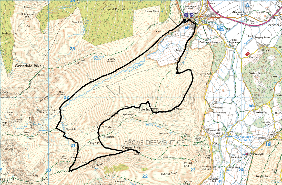
Scar Crags, Causey Pike, Outerside & Barrow - Monday 8 January 2024
Route
Braithwaite - Force Crag Mine Road - Coledale Beck - Birkthwaite Beck - Sail Pass - Scar Crags - Causey Pike - High Moss - Outerside - Low Moss - Stile End - Barrow Door - Barrow - Barrow Gill - Braithwaite
Parking
Plenty of options for parking in Braithwaite. We parked to the left of Braithwaite Chapel (Grid Ref NY 229236, nearest postcode CA12 5TL) just a few hundred yards from The Coledale Inn. Please park sensibly in the parking area to the left of the church in the designated section and not on grass verges.
Mileage
8.1 miles
Terrain
Good mountain paths throughout. The terrain was frozen above 500ft therefore I donned microspikes from just below the Sail Pass until I made my descent from Causey Pike.
Weather
Despite being bitterly cold the weather was sunny with excellent visibility.
Time Taken
4hrs 35mins
Total Ascent
2450ft (747m)
Wainwrights
4
Map
OL4 - The English Lakes (North Western Area)
Walkers
Dave & Fudge
GPX File
|
|
If the above GPX file fails to download or presents itself as an XML file once downloaded then please feel free to contact me and I will send you the GPX file via e-mail.
Route Map
The Old Methodist Chapel in Braithwaite. In 2017 the Orthodox Church of St Bega, St Mungo and St Herbert purchased the chapel. The parking area is to the left where there is room for about 9 cars.
The parking area to the left of the church. We headed up the lane to a footbridge which crosses Coledale Beck
The footbridge over Coledale Beck - it was extremely icy therefore Fudge and I took our time crossing it
Near the footbridge is a wooden seat with a quote from William Henry Davies' poem "Leisure" written in 1911.
What is this life if, full of care
We have no time to stand and stare
No time to stand beneath the boughs
And stare as long as sheep or cows
No time to see, when woods we pass
Where squirrels hide their nuts in grass
No time to see in broad daylight
Streams full of stars, like skies at night
No time to turn at Beauty's glance
And watch her feet, how they can dance
No time to wait till her mouth can
Enrich that smile her eyes began
A poor life this if, full of care
We have no time to stand and stare
William Henry Davies (1871 - 1940) was a Welsh poet who started out as a tramp but ended up a respected poet. Raised by his grandparents after his Father died and his Mother remarried, William was inclined towards a life of adventure. He travelled by boat to North America repeatedly before losing a leg in attempting to jump a train. He eventually returned to England, wrote a book about his wandering years, paid and starved his way into becoming a published poet and, eventually gained equal standing with such contemporaries as W B Yeats & Ezra Pound.
Crossing the bridge, the path rises through woodland passing another seat
Continuing to rise steeply, the path reaches a hand gate
Looking back to Braithwaite from the hand gate
Eventually the path joins the access road for Force Crag Mine - Stile End & Outerside are the fells over to the left
A little further along the Force Crag road, Crag Hill pokes its head out of the cloud over to the left. The weather was starting to improve now which would hopefully last out until we were back in Braithwaite.
At Grid Reference NY 20266 21834 a path heads off to the left leading to a ford over Coledale Beck. If so desired, walkers can continue along the access road to Force Crag Mine. Fudge suddenly seems particularly interested in wandering along the track but sadly we had fells to climb and therefore headed left.
Large stones provide a makeshift bridge over Coledale Beck. Fudge meanwhile waites for the command from me to commence arsing about.
Force Crag with the mine buildings below
Force Crag Mine was the last working metal mine in the Lake District, prior to its final abandonment in 1991. The site was mined for lead from 1839 until 1865, and for zinc and barytes from 1867. The job of the mill in the centre was to separate these minerals from each other, and from any other minerals and the country rock. It is a Scheduled Ancient Monument, and a geological SSSI (site of special scientific interest). The mine occupies a spectacular location at the head of the Coledale Valley. The mill buildings were built in 1908-9 and redesigned in 1939-40. The mill contains the ore-refining machinery that was in use during the 1980s. It is the only former mineral mining site in the country that has retained its processing equipment in something approaching complete order. The National Trust now owns the site and access to the processing mill buildings and machinery was restored in 2004. Visitors can discover what was mined and follow the processing of the minerals through the mill plant.
Arsing about now complete, Fudge looks at me clearly wondering if there is any scran going spare
A little way up from the ford the path splits once more marked by a cairn. We were heading to the left which would take us to High Moss and onwards to the path leading to the Sail Pass. Heading to the right leads to Coledale Hause.
Looking back to Force Crag Mine with Grisedale Pike beyond
Looking to my right over to Coledale Hause with Eel Crag to the left
Continuing up on the path to High Moss with Outerside to the left. It was at this point that the ground was starting to feel very frozen meaning it would soon be time to don my micro spikes.
Looking back down Coledale to Kinn with Skiddaw beyond
Another great view back to Force Crag Mine & Grisedale Pike
Another path junction however this time we were heading to the right - the path to the left leads to Outerside
The path across the lower slopes of Scar Crags that leads to the Sail Pass
Looking to Coledale Hause with Sand Hill centre and Hopegill Head poking out beyond
Right Fudge, I'm going to pop the old micro spikes on now as it is starting to get a bit tasty on this frozen stuff
And here we are - the best £50 I ever spent. I had my winter boots on today and they just stretch over them pretty easily.
Finally we reach the Sail Pass and time for a bit of lunch
Lunch over, it was time to head gently up Scar Crags west ridge
The zig zag path to Sail. As can be seen, the zig zag path is very clear on the ground however it doesn't stop idiots taking a short cut instead of using the path.
Approaching the summit of Scar Crags. It was very windy along the approach and just before this pic was taken I exchanged pleasantries with a chap coming towards me. After a brief chat he said it would be a good idea to put a coat on Fudge as it was very cold at the summit. I didn't have the heart to tell him that Fudge already had a coat on - I simply nodded and wandered on.
The summit of Scar Crags
Whiteside, Sand Hill, Hopegill Head & Grisedale Pike from Scar Crags
The summit of Scar Crags looking to Sail, Crag Hill, Whiteside, Sand Hill & Hopegill Head
Looking down on Outerside from Scar Crags
The ridge walk to Causey Pike from Scar Crags - and what a lovely walk it is
Ard Crags from the ridge to Causey Pike - and layers & layers of fells beyond
Looking back along the ridge to Scar Crags
Braithwaite & Skiddaw over Barrow Door with Stile End left & Barrow to the right
Approaching the summit of Causey Pike
The superb view from Causey Pike's summit back along the ridge to Scar Crags
Rowling End from the summit of Causey Pike
Stile End & Barrow with Barrow Door in between
Fudge on the summit of Causey Pike
From the summit we retraced our steps back along the ridge to Grid Reference NY 21566 20886. Here a path leaves off to the right at a cairn and makes its way down the fell side to High Moss.
Descending to High Moss with Grisedale Pike beyond
Outerside above High Moss
Looking back to our descent path from Causey Pike
Sail, Crag Hill & Eel Crag from the ascent of Outerside
Force Crag Mine & Grisedale Pike from Outerside
The summit of Outerside
Causey Pike from Outerside
Looking back to Outerside from the approach to Stile End
The summit of Stile End
Barrow & Barrow Door from Stile End
Heading down to Barrow Door from Stile End
Causey Pike from Barrow Door
The summit of Barrow looking to Cat Bells
Fudge has a bit of a sniff as we start our descent from Barrow with Braithwaite below
At Grid Reference NY 22999 22392 the path splits and Fudge as usual waits for instruction as to which way he should go. We would be taking the path to the left which returns to Braithwaite via Barrow Gill - the path to the right returns to the village via Braithwaite Lodge.
Dropping down to the crossing point over Barrow Gill
Crossing Barrow Gill
After crossing Barrow Gill the route climbs up to a track that would return us to Braithwaite
Silly not to I suppose after such a cracking day out