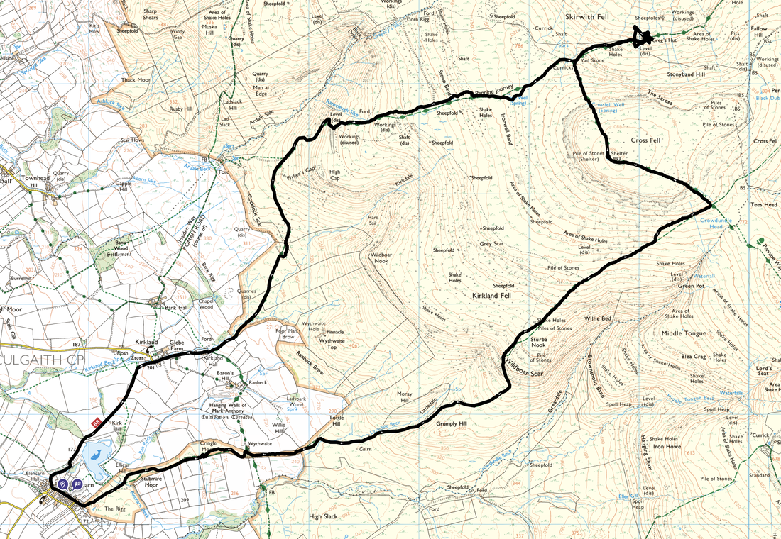
Cross Fell - Saturday 25 November 2023
Route
Blencarn - Kirkland - Kirkland Hall - Plylier's Gap - Stoop Band - Yad Stone - Greg's Hut - Cross Fell - Crowdundle Head - Wildboar Scar - Littledale - Wythwaite - Blencarn
Parking
Parking sensibly on the roadside in Blencarn. The nearest postcode is CA10 1TX.
Mileage
12.6 miles
Terrain
Good mountain paths generally with some slightly boggy sections, farm tracks and some road walking along quiet lanes. The ground was frozen in places therefore care needed to be taken.
Weather
Gloriously sunny yet cold with light breezes on the ridges.
Time Taken
6hrs
Total Ascent
3405ft (1038m)
Map
OL31 North Pennines - Teesdale & Weardale
Walkers
Dave & Fudge with members of Lakeland Meet Ups
GPX File
|
|
If the above GPX file fails to download or presents itself as an XML file once downloaded then please feel free to contact me and I will send you the GPX file via e-mail.
Route Map
The village of Blencarn - the start of todays walk. We parked on the main road near the old school which is now the Village Hall
Heading north west out of the village a road heads off to the right towards Kirkland
The route passes to the right of the entrance to Blencarn Lake Fly Fishing
The early morning sun rises above Blencarn Lake
Blencarn Lake is as natural looking a body of water as you will come across, spring fed from Cross Fell and the upper Pennines. It is however a man-made lake, the idea and the legacy of Ken Stamper, late of Blencarn Hall, who created this place of beauty from a boggy piece of farm land. The lake has offered scenic and peaceful trout fishing since then. Extending to fifteen acres, the water is home to the indigenous brown trout and is stocked regularly with rainbow trout.
I had to look twice at these sheep as they appeared to be sporting Swastikas
Entering the tiny village of Kirkland. The route passes straight through the village and out the other side.
Kirkland Hall
The massive bulk of Cross Fell looms large as we head out of Kirkland - our return route via Wildboar Scar is over to the right
Looking over to Man at Edge
The distant Northern Fells of the Lake District
Black Doors & Ardale Beck
Nearing Cross Fell the route heads across Stoop Band
Above Stoop Band we reached the Pennine Way marker stone. Our route had brought us in past the cairn to the rear and therefore we would ordinarily have turned right to gain Cross Fell, however we were off for lunch at Greg's Hut first.
Just before Greg's Hut a gate is reached leading to some old mine levels & spoil heaps
Fudge eyes Greg's Hut suspiciously from above - I don't know what the problem was. He has been here loads of times before, plus it was lunchtime. We passed by here during our Pennine Way walk in 2015 and were glad of the chance to dry off after a real soaking coming off Cross Fell.
Greg's Hut
Greg’s Hut was originally built as a blacksmith’s shop and in the early 1880’s was used to house miners who lived here during the week while working on the nearby Katelock lead mine. Situated near to the summit of Cross Fell, the bothy was renovated in 1968 in memory of John Gregory and provides shelter for walkers on the nearby Pennine Way. It has had a major refurbishment recently and is maintained jointly by the Mountain Bothies Association and the Greg’s Hut Association.
If you say so
The portrait of John Gregory which hangs in Greg's Hut
A link to more information about John Gregory and the history of Greg's Hut can be found here
A lone tree stands outside Greg's Hut, suitably protected from the elements
As can be seen, it was a tad nippy today
Back at the marker stone, it was time to make our ascent up to Cross Fell
The group passing one of the stone cairns on the way to the summit
Fudge poses at the second cairn which is just before the summit
The impressive summit shelter that marks the summit of Cross Fell - at 2930ft (893m), this point is the highest in England outside of the Lake District National Park. We were up here in 2014 when the shelter was being refurbished and a blog of that walk can be found here
The group plus Fudge pose at the Trig Point on the summit of Cross Fell
From the summit we headed south east towards Crowdundle Head. Little Dun Fell is to the rear with the domed radar station just about visible on the summit of Great Dun Fell.
Great Dun Fell is a little bit clearer now as we drop down to Crowdundle Head - we would be turning to the south west (right) in the direction of Wildboar Scar
Mist sweeps across the moorland as we near Wildboar Scar
Heading back to Blencarn with Grumply Hill ahead
The sun sets over a placid bovine as we arrive at Blencarn