Bowscale Fell, Bannerdale Crags & Souther Fell - Tuesday 28 November 2023
Route
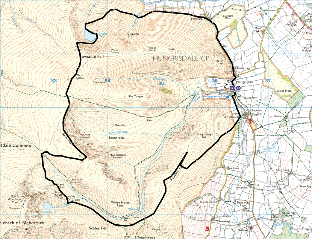
Mungrisdale - Bowscale - Drycomb Beck - Bowscale Tarn - Tarn Crags - Bowscale Fell - Bannerdale Crags - Scales Beck - Souther Fell - Low Beckside - Mungrisdale
Parking
Opposite the Village Hall in Mungrisdale (Donation) - Grid Ref NY364302 (Nearest Postcode is CA11 0XQ)
Mileage
9.5 miles
Terrain
Good mountain paths throughout. The ascent to the col above Bowscale Tarn is steep and on a loose stone path which requires hand on rock for some sections. Due to the weather the ground in some areas was frozen although micro spikes were not used.
Weather
A crisp yet cold day with one snow flurry. The light & visibility were very good.
Time Taken
5hrs 20mins
Total Ascent
2057ft (627m)
Wainwrights
3
Map
OL5 - The English Lakes (North Eastern Area)
Walkers
Dave & Fudge with Sioelan Toja, Andy Carter, Sara Boyle & Christine Backhouse
GPX File
|
|
If the above GPX file fails to download or presents itself as an XML file once downloaded then please feel free to contact me and I will send you the GPX file via e-mail.
Route Map
Today's walk started from the Village Hall in Mungrisdale
The Car Park operates on an "honesty" basis - just poke your cash in the slot and off you go
From the Car Park a sloping path leaves the road to the right and heads to a gate - alternatively you can stay on the road
From the gate a path heads across a field to rejoin the road - the fell centre left is Bowscale Fell Far East Top
Looking back to Mungrisdale with Souther Fell, Bannerdale Crags & The Tongue to the rear
St Kentigern's Church, Mungrisdale
There have been several buildings on this site with the present Church being built in 1756. It is a simple structure with thick rubble stone walls. The interior is simple but contains some interesting features amongst which is a three decker pulpit.
The boundary stone marker as we cross from Mungrisdale into Bowscale
Entering the hamlet of Bowscale a farm track leaves the road on the left and continues to pass a few cottages to reach a gated bridleway. This route leads to Bowscale Tarn which in Victorian times was a very popular tourist spot - so much so that the "holiday makers" were transported there by pony.
Looking to the hamlet of Mosedale with Carrock Fell beyond
Passing several sheep pens, Fudge waits impatiently as we continue up the access track
The River Caldew wends its way up the valley as we continue en route to Bowscale Tarn
The path to Bowscale Tarn continues through the valley to round the north ridge of the fell
At Grid Reference NY 33842 31638 an indistinct path leaves the main route to the left. This path leads to the eastern shoreline of Bowscale Tarn. We remained on the main path.
Looking back to the lower slopes of Carrock Fell and our outward route
Bowscale Tarn - somebody has already wandered in for his morning dip and arse about
The northern shoreline of Bowscale Tarn - our path up to the summit ridge can be seen to the rear making its way from left to right
Bowscale Tarn from the eastern shore
The route up on to the north ridge of Bowscale Fell. It should be noted that whilst this route is actually a path on the ground, some of it is not marked on the OS Map.
Bowscale Tarn from the climb
There is a story that the tarn contains two immortal fish and they were famous enough for Wordsworth to include them in his poem “Feast of Brougham Castle”
Both the undying fish that swim
In Bowscale tarn did wait on him;
The pair were servants of his eye
In their immortality;
The “him” they were waiting on was Lord Clifford (the Shepherd Lord)
Ascending the path to the col on Tarn Crags - whilst steep and over loose stone the going is not overly difficult in good conditions
Great Calva & Knott from Bowscale Fell
Once the climbing was done, all that was left to do in order to reach the summit was to wander over on a lovely grassy path
Looking back to our exit point on Tarn Crags above Bowscale Tarn
Looking to Bowscale Fell Far East Top
Approaching the summit of Bowscale Fell with Bannerdale Crags & Blencathra beyond
The stone shelter that marks the summit of Bowscale Fell
The Tongue with the valley of Bannerdale to the right - the path across the top plus the one below both lead to Mungrisdale
The eastern cairn near the summit of Bannerdale Crags which sits on the edge of the escarpment
About 100 or so yards from the eastern cairn is the actual highest point which is marked by a few stones
Bowscale Fell from the summit of Bannerdale Crags
Sharp Edge, Foule Crag & Blencathra from Bannerdale Crags
From the summit our route headed west down to a col below Blencathra. Arriving at the col there are a myriad of paths to choose from depending on where you want to go. There are two paths that head to the left - the upper path (visible here) heads to the south of the River Glenderamackin whilst the lower path (not visible) heads above the north bank of the river. Both paths lead to the col between Mousthwaite Comb & Souther Fell. The other paths lead to Blencathra & Mungrisdale Common.
The two paths heading down the valley with the River Glenderamackin below - for a change we took the path to the right
Sharp Edge in silhouette
Fudge gives it the "Dad can I go in the water please?" look as we cross Scales Beck
Scales Beck cascading down from the tarn of the same name with Brunt Knott to the right
Looking back up the col between Blencathra & Bannerdale Crags
White Horse Bent to the left with Souther Fell to the right
The path to Souther Fell from above Mousthwaite Comb
Sharp Edge & Blencathra from above the col with White Horse Bent to the right and Scales Fell to the left
Bannerdale Crags with Blencathra beyond from Souther Fell
A few yards off the main path is a solitary cairn which Wainwright sketched for his Pictorial Guide (Souther Fell 2)
The summit of Souther Fell South Top - as is tradition, Fudge marks the summit due to the absence of a suitable cairn. The actual summit of the fell can be seen to the distant left.
The rock that marks the summit of Souther Fell with Bannerdale Crags & Bowscale Fell to the rear
From the summit there are two ways to return to Mungrisdale one of which is to continue north and descend steeply to reach Low Beckside. Today however we would return via a gentler descent - we retraced our steps to Grid Reference NY 35353 28925. Here a path leads off to the left and after 200 yards meets another path coming in from the right at Grid Reference NY 35486 28864. This path is a much gentler descent to Low Beckside and eventually Mungrisdale.
Doesn't matter how small the water is - he will arse about in it
Great Mell Fell
Mungrisdale ahead as we descend gently back to the start
Tempted but saved it for another day - and it was shut anyway!!
From The Mill Inn a wooden bridge crosses the River Glenderamackin to reach the parking area in Mungrisdale