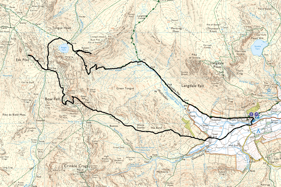
Bowfell, Esk Pike & Rossett Pike - Wednesday 13 December 2023
Route
Old Dungeon Ghyll (ODG) - Stool End - The Band - White Stones - Earing Crag - Climber's Traverse - Great Slab - Bowfell - Ore Gap - Esk Pike - Ore Gap - Angle Tarn - Rossett Pike - Rossett Gill - Mickleden - ODG
Parking
The National Trust Car Park at the Old Dungeon Ghyll Hotel (charge although free for members). The Car Park is located at Grid Reference NY 286061 and the nearest postcode is LA22 9JY.
Mileage
9.7 miles
Terrain
Good mountain paths mostly. The Climber's Traverse beneath Bowfell has some very mild exposure.
Weather
A mixed bag today - dry with low cloud until late morning which cleared in the afternoon.
Time Taken
7hrs 20mins
Total Ascent
3343ft (1019m)
Wainwrights
3
Map
OL6 - The English Lakes (South Western Area)
Walkers
Dave & Fudge with Nicky Oliver & Trev Bailey
GPX File
|
|
If the above GPX file fails to download or presents itself as an XML file once downloaded then please feel free to contact me and I will send you the GPX file via e-mail.
Route Map
The walk started from the National Trust Car Park next to the Old Dungeon Ghyll Hotel
The view down the Langdale Valley from the Car Park
The Band looms large over to the left as we leave ODG on the path to Stool End Farm
Kettle Crag & Pike O'Blisco from the path to Stool End Farm
Side Pike with Lingmoor Fell to the left
As we neared Stool End Farm the low cloud was lingering on both Crinkle Crags & Bowfell - would it lift later?
The Band ahead now as we near Stool End Farm
Stool End Farm - nice & tidy
Golden sunlight on the Langdale Pikes - Pike O'Stickle, Loft Crag & Harrison Stickle across Mickleden
Looking back to Stool End & Langdale from the start of The Band's ascent
Ascending The Band, the path passes the memorial bench to Mr S H Hamer, Secretary of the National Trust 1911 - 1934
Pike O'Blisco across Oxendale
A little further up The Band and the sun continues to shine on the Langdale Pikes
Crinkle Crags
After a while the ascent of The Band levels out and the lower crags of Bowfell come into view
Fudge waits for route guidance although secretly I think he knows which way we are going today. At Grid Reference NY 25550 06133 the path splits and an indistinct path heads off to the right with the main path to Three Tarns continuing on to the left. The path on the right leads to The Climber's Traverse. The name Climber's Traverse should not put people off - it is so called because the route traverses across the eastern face of Bowfell and was initially used by climbers as a convenient way to access the various pitches on Bowfell Buttress.
Fudge gives us his "get a bleedin' move on" face as we start The Climber's Traverse
Looking back to a gloomy The Band as we head along The Climber's Traverse
Continuing along The Climber's Traverse with Bowfell Buttress just about in view ahead
Whilst from here the path looks very exposed, it never really feels like it. We just took our time and watched our feet.
The path continues on to reach a rock groove
The base of Cambridge Crag which marks the point at which the ascent to the side of Great Slab of Flat Crags begins to the left. There is normally water gushing out of the rock but there was very little today. The party junction is located at Grid Reference NY 24609 06599.
The start of the ascent up the side of Great Slab
Bowfell Buttress from the ascent of Great Slab
Great Slab now in view as we continue our ascent
By this time the weather had really closed making photography nigh on pointless. We did however grab this pic of Bowfell's summit looking into a thick grey soup.
The path to Ore Gap from Bowfell
The cairn at the top of Ore Gap with the path to Esk Pike ahead - we would be doing a quick out & back there today
The summit of Esk Pike - again no views unfortunately
Ore Gap from the descent of Esk Pike - was the weather about to improve?
Whey hey - yes it was! The descent from Ore Gap looking to Allen Crags & Glaramara
Angle Tarn below with Rossett Pike & the Langdale Pikes beyond - High Raise is a distant left
Rossett Pike, Angle Tarn & Hanging Knotts on Bowfell
A clearer view of Angle Tarn & Hanging Knotts - by this time a furry little chap was getting excited
And this was why!
Above Angle Tarn a cairn is reached and from here it is a short walk over to Rossett Pike
Looking over to The Climber's Traverse and Great Slab from Rossett Pike
Nicky, Trev & Fudge on the summit of Rossett Pike with the Langdale Pikes providing the backdrop
It is worth making the short walk over to Rossett Pike's eastern cairn for this fantastic view down Mickleden
We would be returning to Langdale via the Rossett Gill path which can be seen below
Descending the Rossett Gill path to Mickleden
The junction of paths at the head of Mickleden - we had come from the Esk Hause direction and were off to Langdale which is to the right. The path directly ahead is the Stake Pass which heads to Langstrath and is also the route of The Cumbria Way.
Pike O'Stickle from Mickleden
The long, long walk through Mickleden back to Langdale